


The total area of Bangladesh is 56,977 square miles (1,48,393 square kilometer). In 2011, the estimated population of the country was 142,319,000. In the Map of Bangladesh, 8 divisions and districts are showing separately. Bangladesh is a sovereign state & join its borders with India from west, north, east sides except for Mayanmer in the south-east & Bay of Bengal in the south. From this article, you will know how many division in bangladesh? and Bangladesh district map.
Map of Bangladesh
This Bangladesh Map also highlights the capital city, other major cities, districts, and political map of Bangladesh. Dhaka, the capital of Bangladesh is clearly stands in the center of the map. Dhaka is located on the banks of River Buriganga. It is known as the “City of Mosques”.
The other main cities of Bangladesh are Chittagong, Khulna, Rajshahi, Sylhet, Rangpur, Barisal, Mymensingh are also administrative divisions of the Bangladesh. Dhaka and other 8 divisions divided into 64 districts.
How many Divisions in Bangladesh?
There are 8 Divisions in Bangladesh are Dhaka, Chittagong, Rajshahi, Khulna, Rangpur, Sylhet, Barisal and Mymensinngh (new division ).
Proposed Divisions are Comilla Division, Faridpur Division and Noakhali Division.
Division of Bangladesh
Showing Barisal Division in Bangladesh Map :
Barisal division is situated in the south of Bangladesh, Boarding division are Khulna in the west, Chittagong in the south and Dhaka in the north.
Main City: Barisal
District : 6
Upazila: 39
Union ParishadUnion Parishad: 333
Area: 13,225.20
Population: 8,325,666
Summary of Chittagong Division :
Chittagong is situated on south-east side of the of Bangladesh. Chittagong Division is boarding by Barisal in the west, Dhaka and Sylhet in the West-North sides of the Bangladesh. World Longest sea beach is also located on the bay of Bengal, South of the Chittagong.
Main City: Chittagong
District : 11
Upazila: 97
Union Parishad: 336
Area: 33,908.55
Population: 28,423,019
Summary of Dhaka Division :
Dhaka is the situated in the center of Bangladesh sounding by Rajshahi, Khulna, Barisal, Chittagong and Mymensing.
Main City: Dhaka
District : 13
Upazila: 93
Union Parishad: 1833
Area: 20,593.74
Population: 36,054,418
Fact of Khulna Division :
Khulna Division is situated in the South-West Side of Bangladesh. Dhaka and Barisal is in the East side of the map of Bangladesh.
Main City: Khulna
District : 10
Upazila: 59
Union Parishad: 270
Area: 22,284.22 km2
Population: 15,687,759
Knowing New Mymensingh Division location in Bangladesh Map :
The Dhaka Division was divided into two are Dhaka and Mymensingh Division. Mymensing Division is situated on the North of the Bangladesh. Sylhet in the south, Rangpur in the North-West and Rajshah in the West of Mymensingh Division.
Main City: Mymensingh
District : 4
Upazila: 34
Union Parishad: 350
Area: 10,584.06 km2
Population: 11,370,000
North area Bangladeshi Map with Rajshahi Division :
Rajshahi Division is adjourn to Dhaka Division, just west side of Dhaka. Other Bordering divisions are Mymensing in the East and Rangpur in the North.
Main City: Rajshahi
Total District : 8
Upazila: 70
Total Union Parishad: 558
Area: 18,153.08 km2
Population of Rajshahi Division: 18,484,858
Summary of Rangpur Division :
Rangpur Division is situated in the north side of Bangladesh. Boarding division is Rajshahi in the South, Mymensingh in the South-East.
Main City: Rangpur
Total District : 8
Upazila: 58
Total Union Parishad: 536
Area: 16,184.99 km2
Population of Rangpur Division: 15,787,758
Summary of Sylhet map:
Sylhet Division is situated on the North-East side the Bangladesh. Sylhet is famous is for Beautiful tea Garden.
Main City: Sylhet
Total District : 4
Upazila: 38
Total Union Parishad: 334
Area: 16,184.99 km2
Population of sylhet Division: 9,910,219
Bangladeshi map New with all eight divisions
Bangladesh Maps
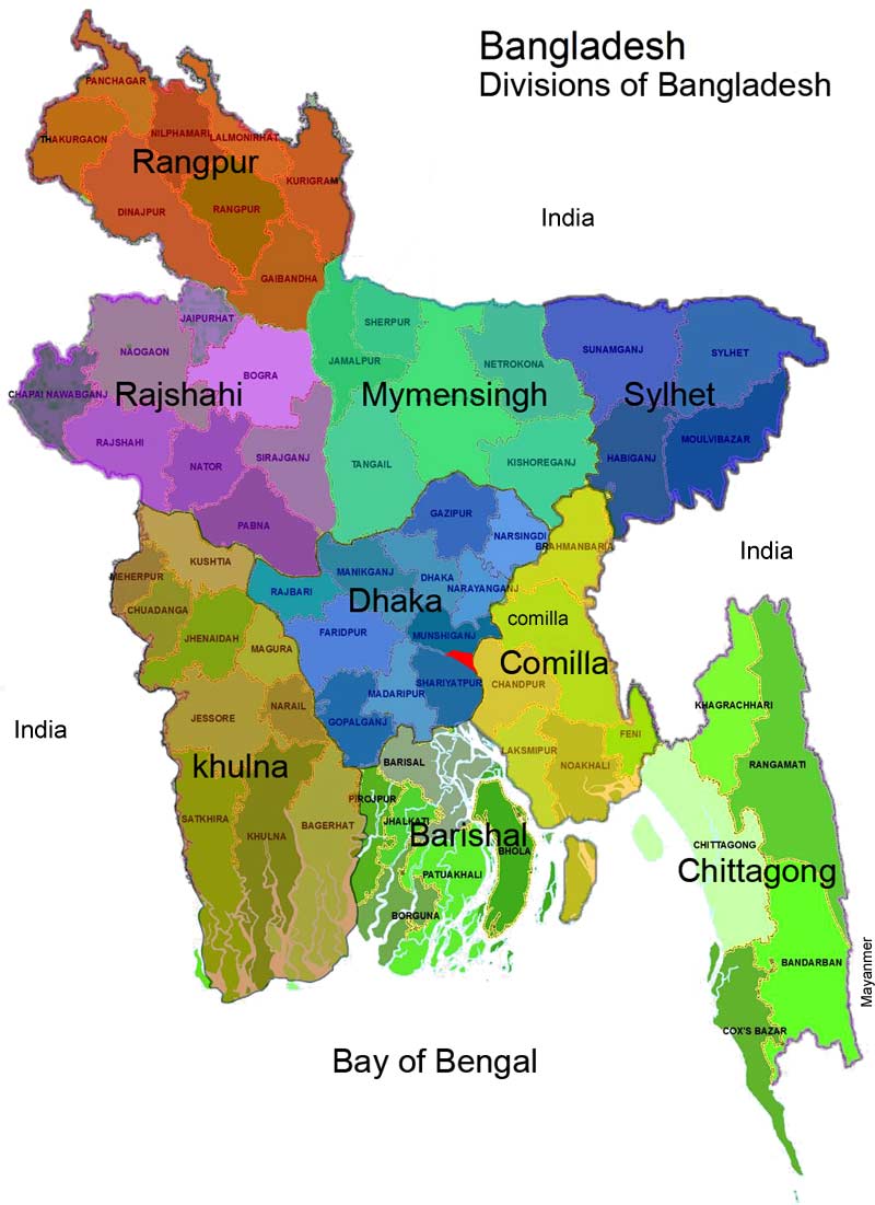
Above Bangladesh Map Picture is indicated divisions with different colors. Bangladesh map 64 districts showing under the division of Bangladesh.
Position of Divisions.
- Dhaka division is in the middle of Bangladesh with bordering Barisal, Khulna, Comilla, Mymensingh, Rajshahi.
- Rajshahi Division in north-west of Bangladeshi Map with boarding Khulna, Mymensing and Dhaka.
Sylhet Division in the North-east of Bangladesh Map with boardering Mymensing and Comilla. - Chittagong Division is in the East-South of Bangladesh map with boardeing Barisal and Dhaka.
- Barisal division is in the North of Bangladesh Map with bordering Dhaka, Khulna and Chittagong.
- Khulna is in the South-west of Bangladesh with bordering Barisal, Rajshahi and Dhaka.
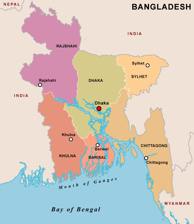
Old Political Map
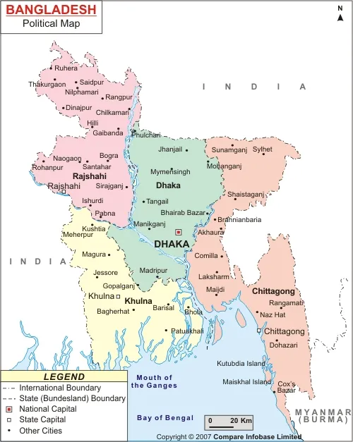
Bangladesh district map
The district map of Bangladesh is a detailed representation of the administrative divisions that organize the country’s territory. Bangladesh, a South Asian country with a rich history and vibrant culture, is divided into eight administrative divisions: Dhaka, Chittagong, Rajshahi, Khulna, Barisal, Sylhet, Rangpur, and Mymensingh. Each division is further divided into districts, making the country’s governance more manageable and localized.
As of now, Bangladesh comprises 64 districts, known locally as “zilas.” Each district is governed by a District Commissioner, who oversees administrative functions, law enforcement, and the implementation of government policies within the district. The districts are further subdivided into upazilas or sub-districts, making the governance structure even more granular and responsive to local needs.
The Dhaka division, being the capital region, holds significant importance. It is not only the most populous division but also the economic, political, and cultural hub of the country. The Dhaka district within this division is densely populated and is home to the nation’s capital city, Dhaka. The division also includes other prominent districts like Narayanganj, Gazipur, and Tangail, each playing a crucial role in the country’s economy.
Chittagong division, located in the southeastern part of Bangladesh, is another vital region. It includes the Chittagong Hill Tracts, which are known for their unique culture and natural beauty. Chittagong, the largest port city of Bangladesh, falls under this division and serves as the country’s commercial gateway. The division also includes districts like Cox’s Bazar, known for having the world’s longest natural sandy sea beach, and Feni, which has significant historical importance.
Rajshahi division, situated in the northwest, is known for its mangoes and silk. The city of Rajshahi, often referred to as the “Silk City” and “Education City,” is the division’s administrative and educational center. Khulna, on the other hand, is an important division in the southwest, known for the Sundarbans, the largest mangrove forest in the world and home to the Royal Bengal Tiger.
Sylhet division, located in the northeastern region, is famous for its tea gardens and natural beauty. Barisal, Rangpur, and Mymensingh divisions also contribute to the diversity and richness of Bangladesh’s cultural and economic landscape.
Understanding the district map of Bangladesh provides insight into the country’s administrative organization and highlights the unique characteristics of each region, reflecting the diversity and dynamism that define Bangladesh.
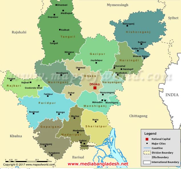
Map of Dhaka Division of Bangladesh
If you compare with Bangladeshi map old one with with new map, you will see new division that separated from old division. There are no chance to increase district, in Bangladesh map 64 districts are existing for many years. Though we have see couple of upazila or Union were divided in upazila or union.
Topographical Features
The topography of Bangladesh is predominantly a vast delta plain formed by the confluence of the Ganges (Padma), Brahmaputra (Jamuna), and Meghna rivers and their tributaries. This delta, one of the largest in the world, is often referred to as the Bengal Delta. The land is mostly flat and low-lying, with an average elevation of just a few meters above sea level. This makes the country highly susceptible to flooding, particularly during the monsoon season.
Despite the dominance of flat plains, the map also features hilly areas, especially in the southeast in the Chittagong Hill Tracts. These hills, part of the Indo-Burman Range, provide a stark contrast to the surrounding plains and are home to diverse ethnic communities with unique cultures and traditions.
Hydrological Significance
The intricate network of rivers is perhaps the most striking feature of the Bangladesh’s Map. The Ganges, Brahmaputra, and Meghna rivers, along with their numerous tributaries and distributaries, create a complex web that sustains the agricultural backbone of the country. These rivers are vital for irrigation, transportation, and fishing, and they play a crucial role in the socio-economic life of the nation.
The Sundarbans, the world’s largest mangrove forest, lies in the southwestern part of Bangladesh, where the Ganges and Brahmaputra rivers meet the Bay of Bengal. This UNESCO World Heritage Site is not only a critical habitat for wildlife, including the Bengal tiger but also acts as a natural barrier against cyclones and tidal surges.
Administrative Divisions
Bangladesh is divided into eight administrative divisions: Dhaka, Chittagong, Khulna, Rajshahi, Barisal, Sylhet, Rangpur, and Mymensingh. Each division is further subdivided into districts, known as Zilas, totaling 64 in number. These divisions and districts are crucial for administrative purposes and help manage the densely populated country efficiently.
Dhaka, the capital city, is located in the central part of the country and serves as the political, economic, and cultural hub. Chittagong, the second-largest city, is a major seaport and commercial center situated in the southeast.
Cultural and Historical Sites
The map is dotted with numerous historical and cultural landmarks. From the ancient ruins of Mahasthangarh and the Buddhist Vihara at Paharpur to the colonial-era architecture in Dhaka and the pristine beaches of Cox’s Bazar, Bangladesh offers a rich tapestry of history and culture. Each region has its own unique heritage, contributing to the diverse cultural mosaic of the nation.
Environmental Challenges
While the rivers are a lifeline for Bangladesh, they also pose significant challenges. The country faces frequent natural disasters, including floods, cyclones, and riverbank erosion, which are exacerbated by climate change. These environmental challenges require effective management and adaptation strategies to ensure the safety and livelihood of its people.
The map of Bangladesh is a testament to its rich natural and cultural heritage. The country’s rivers, plains, hills, and forests create a unique geographical identity that has shaped its history and continues to influence its future. Understanding the intricacies of Bangladesh’s geography is essential for appreciating the resilience and diversity of its people. As the country navigates the challenges of the 21st century, the features highlighted on its map will remain central to its narrative of growth, sustainability, and cultural richness.
")